Super El Niño predicted for 2026 could push Earth past 1.5°C warming threshold permanently
Climate models converge on a peak anomaly of 2.7°C in the tropical Pacific, raising odds that 2027 becomes the hottest year on record.

CANADA —
Key facts
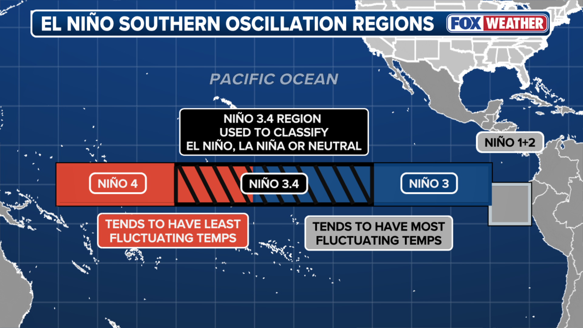
- Multi-model median projection shows a 2.7°C peak anomaly in the ENSO3.4 region for the 2026/2027 El Niño.
- 2026 has a 56% chance of being the second warmest year on record and a 26% chance of being the warmest.
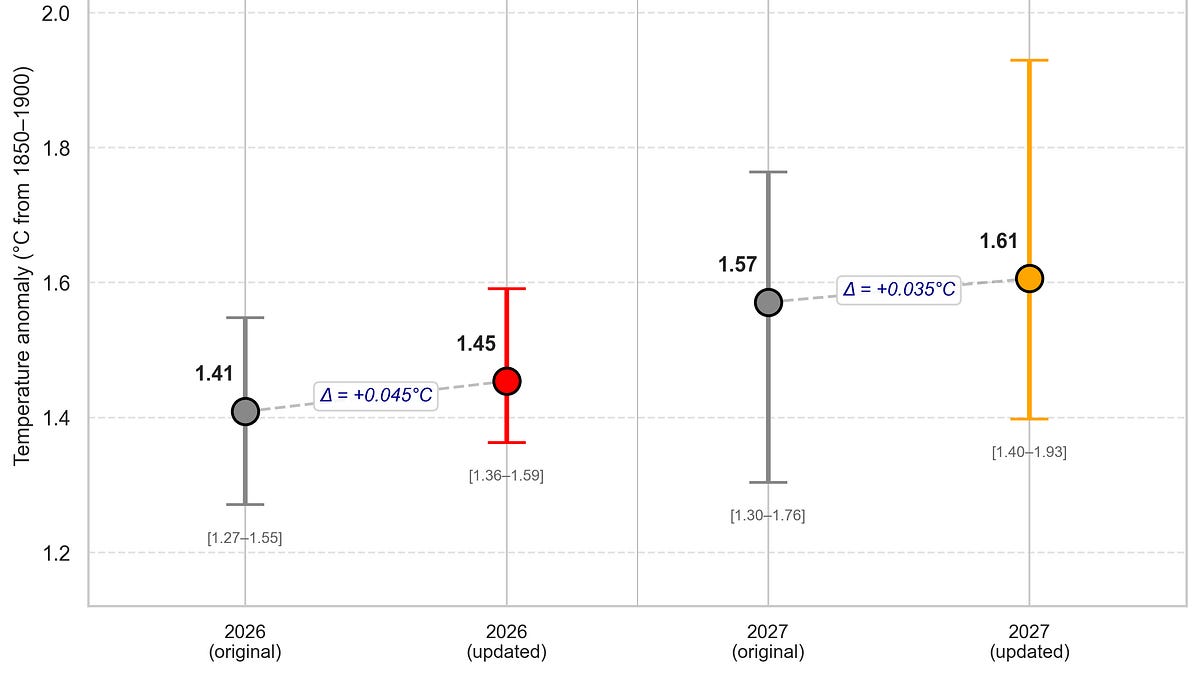
- The 2026 global temperature estimate has been revised upward to 1.46°C above preindustrial levels.
- Super El Niños can trigger abrupt 'climate regime shifts' in heat, rainfall and drought patterns, per a December 2025 Nature Communications study.
- Sea surface temperatures off Mexico are already 2–3°F above average, fueling potential early hurricane development in the Eastern Pacific.
- Super Typhoon Sinlaku hit Saipan with 200 mph winds on April 14, 2026, enhanced by warm Pacific waters.
- Climate scientist James Hansen projects a strong El Niño could drive global temperature to 1.7°C above preindustrial levels.
A brewing ocean heat pulse
The tropical Pacific Ocean is warming toward what could become a 'super El Niño' by late 2026, with climate models now converging on a peak sea-surface temperature anomaly of 2.7°C in the ENSO3.4 region. That would place the coming event on par with the record-breaking 2015/2016 super El Niño. This oceanic heat engine, spanning an area four times the size of the continental United States, periodically shifts its currents and winds, sending vast stores of warm water eastward from the Western Pacific Warm Pool. When that heat spreads across the equatorial Pacific, it spills into the atmosphere, rerouting high-elevation winds, raising global temperatures and disrupting weather patterns worldwide.
Revised temperature forecasts climb higher
Updated projections for 2026 now estimate a global mean surface temperature anomaly of 1.46°C above preindustrial levels, up from a December estimate of 1.41°C. The 2027 forecast has similarly risen to 1.61°C, with a range of 1.4°C to 1.93°C, reflecting the anticipated El Niño boost. The new estimates incorporate a regression model that accounts for year-to-date temperatures, observed and forecast ENSO states, and the long-term warming trend. Monte Carlo simulations propagate uncertainty from both the temperature data and the El Niño forecast, widening the error bars for 2027. The model accurately hindcasts past strong El Niño years such as 1998 and 2016, though it slightly underestimates the jumps in 1973, 1983 and 1998.
The 1.5°C threshold in jeopardy
Even a moderately strong El Niño in the next 12 to 18 months could push the global average temperature to about 1.7°C above preindustrial levels, according to climate scientist James Hansen. Hansen doubts the world will cool back below 1.5°C after the El Niño fades, suggesting the threshold may be crossed permanently. Passing that mark is not a climate cliff but a point where the edge begins to crumble, with rapid changes to stable systems of forests, water and temperature. Already, below 1.5°C, California reservoirs alternate between dry years and extreme floods, coral reefs from Australia to the Caribbean have bleached beyond recovery, and deadly nighttime heat kills vulnerable people in cities.
Super El Niños as systemic shocks
A study published in December 2025 in Nature Communications concluded that 'super El Niños' are not transient weather events but climate shocks that can push parts of the Earth system into new states. Co-author Jong-Seong Kug wrote that these events, defined by sea-surface temperature anomalies exceeding two standard deviations above normal, can trigger abrupt, lasting changes in heat, rainfall and drought patterns. The study found that climate impacts amplified by strong El Niños hit the same vulnerable regions repeatedly, may be more widespread than previously thought, and can persist long after the tropical Pacific cools. This challenges the view of El Niño as a temporary perturbation.
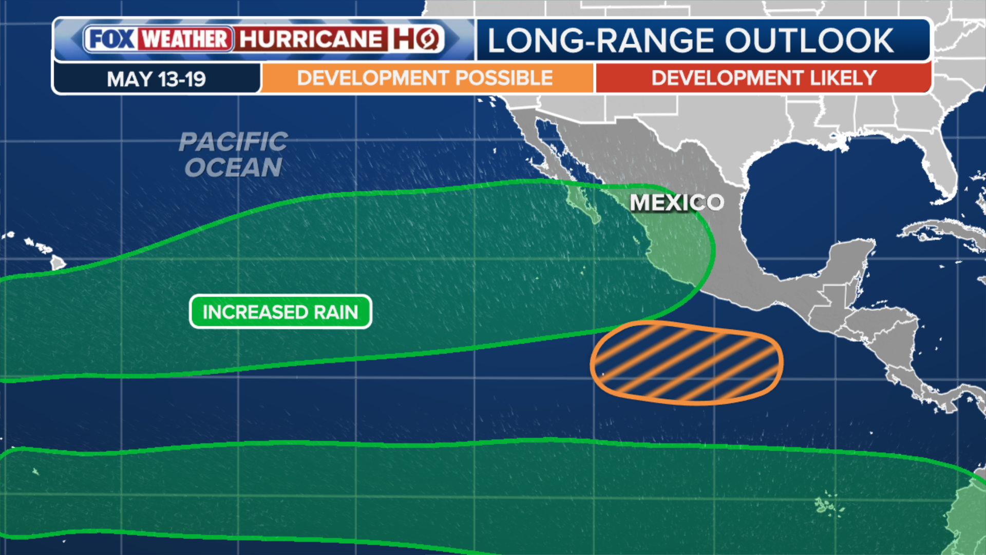
Early hurricane activity in the Eastern Pacific
NOAA's Climate Prediction Center has flagged an area off the southern coast of Mexico for potential tropical development between May 13 and May 19, more than two weeks before the official start of Eastern Pacific hurricane season. Sea surface temperatures in the region are already 2–3°F above average, with localized areas reaching the upper 80s°F — more than sufficient to support tropical cyclone formation. While the first named storm typically forms around June 10, the combination of above-average waters and a developing El Niño suggests a supercharged hurricane season ahead. Warm Pacific waters recently supercharged Super Typhoon Sinlaku, which slammed into the U.S. territory of the Northern Mariana Islands on April 14, 2026, with wind speeds approaching 200 mph.
Outlook: a pivotal 18 months
The 2026/2027 El Niño is still within the 'spring predictability barrier,' making its exact strength uncertain. But the multi-model median projection of a 2.7°C peak anomaly signals a high likelihood of a major event. If realized, 2026 has a 56% chance of becoming the second warmest year on record and a 26% chance of being the warmest, with a 34% probability of exceeding 1.5°C. The consequences would ripple across the globe: intensified rainstorms and flooding in some regions, amplified extreme heat, drought and wildfires in others, and further disruption of fisheries and ocean ecosystems. The 2015 El Niño pushed global temperatures irreversibly past 1°C; the coming one may lock in a new, hotter climate regime.
The bottom line
- A super El Niño with a 2.7°C peak anomaly is projected for late 2026, comparable to the 2015/2016 event.
- 2026 global temperature estimate is now 1.46°C above preindustrial levels; 2027 could reach 1.61°C.
- Super El Niños can trigger lasting 'climate regime shifts' in heat, rainfall and drought, per a December 2025 study.
- The 1.5°C warming threshold may be crossed permanently, with Hansen doubting a return below it.
- Eastern Pacific hurricane season could be supercharged, with early development already possible off Mexico.
- Super Typhoon Sinlaku (April 2026) demonstrated the power of warm Pacific waters, hitting Saipan with 200 mph winds.


Brent crude surges past $126 as Iran tensions roil markets, then plunges 9%

Colorado Snowpack Hits Record Lows as Late-Season Storm Promises Up to Two Feet

Brent crude surges past $126 as stalled US-Iran talks threaten Strait of Hormuz reopening