Super El Niño Threatens Record Global Temperatures
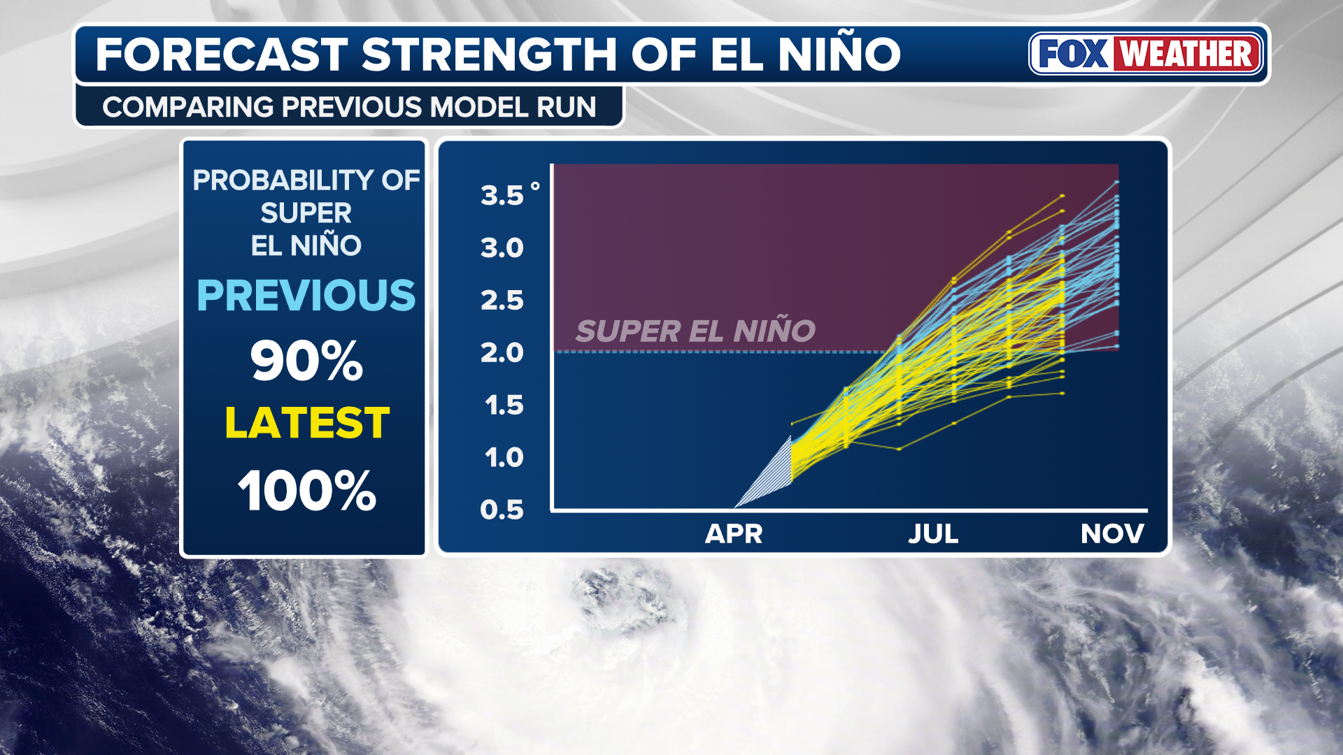
European Centre for Medium-Range Weather Forecasts predicts a 100% chance of a powerful El Niño event by November.

UNITED KINGDOM —
Key facts
- A 100% chance of a super El Niño forming by November is predicted.
- Water temperatures in the central equatorial Pacific could reach 3°C above average.
- This event could surpass records set in 1877 and 2015.
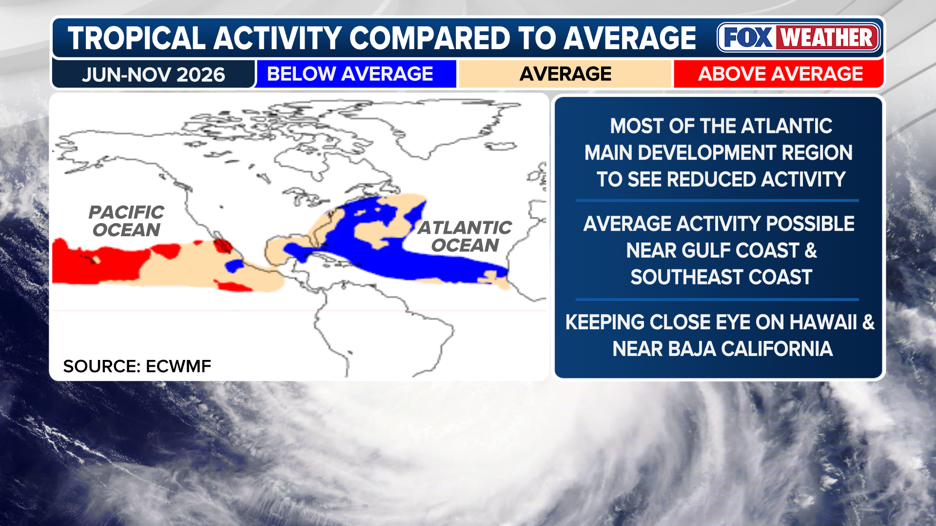
- Hurricane activity in the Atlantic may be suppressed.
- The southern U.S. could experience a wetter fall and winter.
- The forecast suggests near-normal activity in the northern Gulf of Mexico.
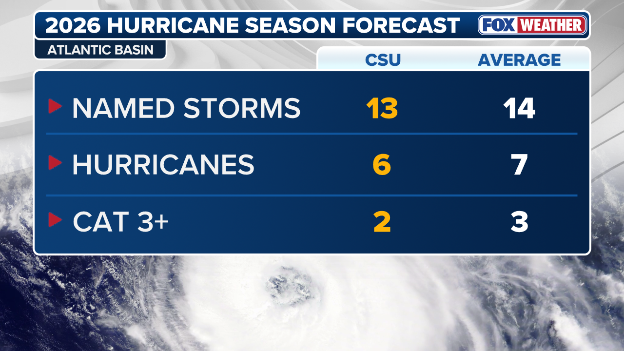
- 13 named storms and 6 hurricanes are forecast for the Atlantic season.
A Potentially Unprecedented El Niño Looms
The scientific community is closely monitoring a developing El Niño event that forecasts suggest could become the most powerful on record. The European Centre for Medium-Range Weather Forecasts (ECMWF) has issued a long-range forecast indicating a 100% probability of a "super" El Niño forming by November. This phenomenon, characterized by significantly warmer-than-average sea surface temperatures in the central equatorial Pacific Ocean, has the potential to reshape global weather patterns for the coming year. The implications of such an extreme event are far-reaching, with initial projections pointing towards a suppression of hurricane activity in the Atlantic basin. However, the ECMWF's models also indicate that ocean temperatures are expected to remain above average throughout the hurricane season, a factor that could still influence tropical storm development. This delicate balance means that while the typical El Niño effect of reduced Atlantic storms is anticipated, the full extent of its impact remains under scrutiny. This latest forecast marks a significant shift from earlier predictions. In March, data suggested only a 55% chance of reaching the super El Niño threshold by September. The current outlook, issued in May, paints a more definitive picture of an event that could be historically significant, potentially influencing weather for years to come.
Record-Breaking Temperatures on the Horizon
The core of the concern lies in the projected intensity of the El Niño. New data released this week indicates that water temperatures in a key region of the central equatorial Pacific Ocean could climb to 3 degrees Celsius (5.4 degrees Fahrenheit) above average by late in the year. Such an increase would not only exceed the threshold for a super El Niño but could also approach or surpass the record temperature anomalies observed in 1877 and 2015. This sustained elevation of ocean temperatures is a defining characteristic of powerful El Niño events. It directly influences atmospheric circulation patterns, leading to widespread climatic shifts. The potential for this event to become one of the most powerful on record has led multiple forecasting models to predict that it could drive global temperatures to new highs. The ECMWF's May long-range forecast model specifically highlights this potential for extreme warmth. The prospect of surpassing previous records underscores the urgency with which scientists are tracking this developing climate pattern and its potential global ramifications.
Impact on Atlantic Hurricane Season
Traditionally, a strong El Niño correlates with reduced tropical storm activity in the Atlantic Ocean. This is primarily due to increased wind shear, which disrupts the formation and intensification of hurricanes. The ECMWF forecast aligns with this expectation, painting a picture of below-average tropical activity across most of the Atlantic's Main Development Region. However, the forecast is not entirely conclusive on a complete shutdown of Atlantic storms. While El Niño is expected to significantly temper activity, the ECMWF is not yet projecting a drastic decrease in the overall number of predicted storms. The latest outlook calls for 13 named storms and 6 hurricanes, which is only slightly below the seasonal average of 14 named storms and 7 hurricanes, according to the FOX Forecast Center. Furthermore, the ECMWF models show above-average ocean temperatures persisting for the duration of the hurricane season. This could create conditions that, despite the presence of El Niño, might still allow for storm development, particularly later in the season. The precise balance between El Niño's suppressive effects and the influence of warmer waters remains a critical factor to monitor.
Regional Weather Shifts Predicted
Beyond the Atlantic tropics, the super El Niño is expected to bring significant precipitation changes to other regions. The forecast indicates a strong likelihood of a wetter fall and winter across the southern United States. This increased rainfall could have implications for agriculture, water resource management, and flood risk in these areas. In contrast, the ECMWF models suggest near-normal activity for the northern Gulf of Mexico. This implies that while the southern U.S. may experience a substantial increase in precipitation, the northern coastal regions might see more typical weather patterns for the season. The hurricane season in the Eastern Pacific, which begins on May 15, is also expected to see increased activity, a common characteristic of El Niño years. As the forecast has been extended, models now consistently show above-average rain across the South, reinforcing the expectation of a wetter period for the region.
A Forecast to Remember
The prediction of an El Niño of this magnitude, being forecast so early in the year, suggests it could be an event that scientists and meteorologists will look back on for years to come. The confluence of a 100% chance of a super El Niño, potential record-breaking global temperatures, and the nuanced impact on hurricane activity presents a complex and significant climate scenario. The European Centre for Medium-Range Weather Forecasts' issuance of its May long-range forecast model has solidified expectations for a powerful El Niño. This event's potential to surpass historical records for intensity and influence global temperatures places it at the forefront of current climate research and monitoring efforts. As the season progresses, continued observation and refinement of these forecasts will be crucial for understanding and preparing for the widespread climatic consequences of this potentially unprecedented El Niño.
The bottom line
- A 100% probability of a super El Niño event forming by November has been predicted.
- This El Niño could be the most powerful on record, potentially setting new global temperature highs.
- Atlantic hurricane activity is expected to be suppressed, though warmer ocean temperatures may still influence storms.
- The southern U.S. is forecast to experience wetter conditions in the fall and winter.
- The event's intensity could surpass records dating back to 1877 and 2015.
- Forecasters are closely monitoring the potential for this El Niño to significantly alter global weather patterns.


Epstein's Alleged Suicide Note Unsealed by US Judge

Ex-LostProphets Singer Ian Watkins Murder Trial: CCTV Shows Attack

Melanie C's New Album Spine Features "Melanine C" Typo
