Super El Niño on Horizon Could Push Planet Past 1.5°C Warming Threshold Permanently
Climate models converge on a peak anomaly of 2.7°C in the tropical Pacific, threatening irreversible shifts in rainfall, drought and heat patterns.
UNITED KINGDOM —
Key facts
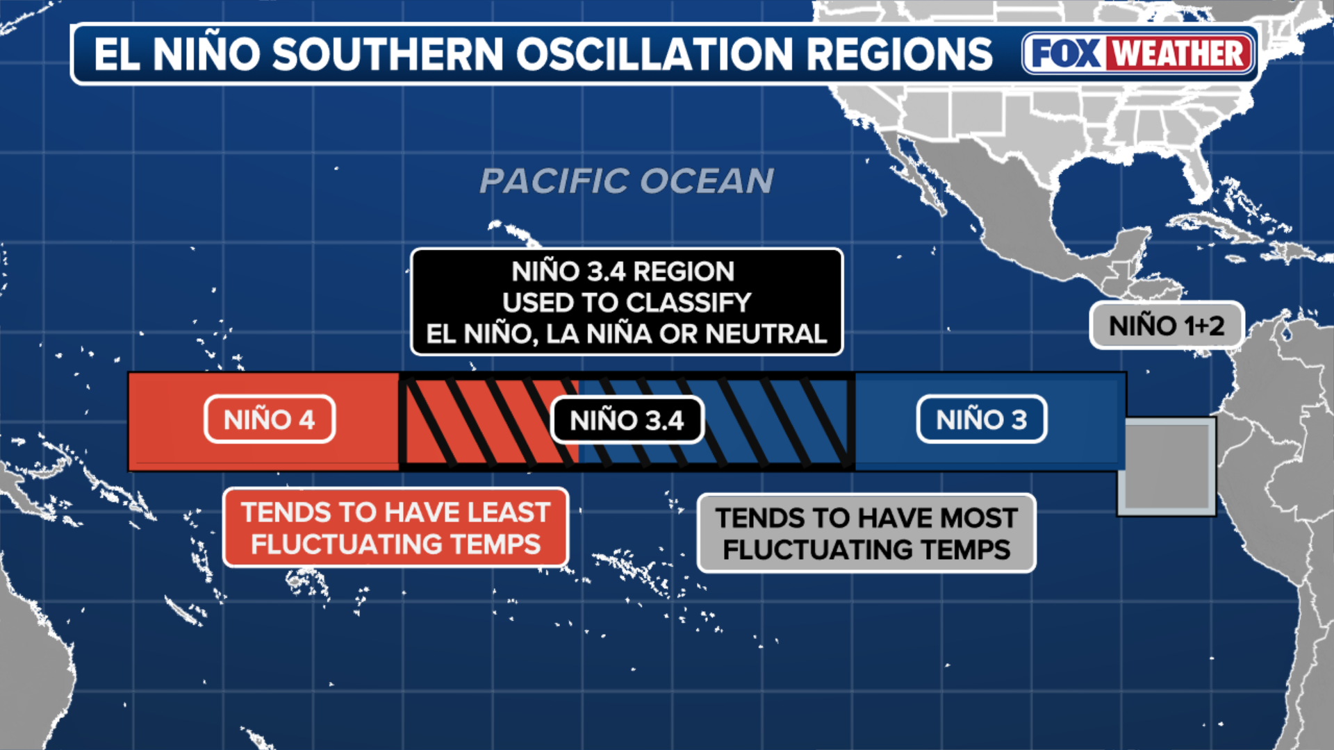
- Multi-model median projection shows a peak El Niño anomaly of 2.7°C in the ENSO3.4 region in late 2026.
- A strong El Niño could drive global average temperature to 1.7°C above preindustrial levels, says climate scientist James Hansen.
- Super El Niños can trigger 'climate regime shifts'—abrupt, lasting changes in heat, rainfall and drought patterns, per a December 2025 Nature Communications study.
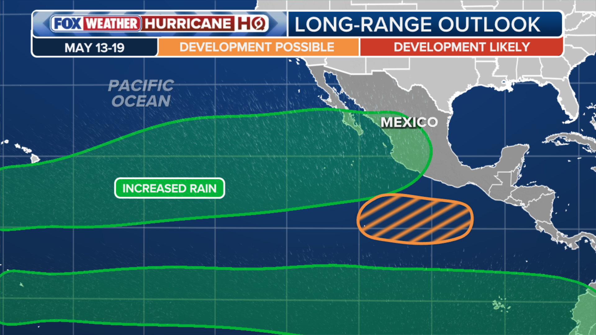
- The Eastern Pacific hurricane season may start early, with NOAA highlighting potential tropical development off Mexico between May 13-19.
- Sea surface temperatures off Mexico are already 2-3°F above average, reaching the upper 80s.
- Super Typhoon Sinlaku hit Saipan with winds near 200 mph on April 14, 2026, boosted by warm Pacific waters.
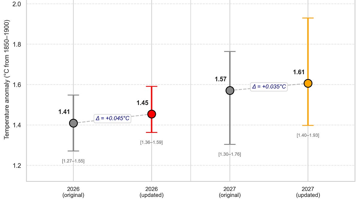
- Updated projections estimate 2026 global temperature at 1.46°C (range 1.36-1.59°C) and 2027 at 1.61°C (range 1.4-1.93°C).
A Pacific Heat Pulse That May Not Fade
The tropical Pacific is simmering toward a powerful El Niño that could permanently push the planet’s average annual temperature past the 1.5 degrees Celsius warming threshold, scientists warn. The latest multi-model projections converge on a peak sea-surface temperature anomaly of 2.7°C in the ENSO3.4 region—comparable to the 2015/2016 super El Niño. That event helped raise the global annual average temperature irreversibly past 1°C above pre-industrial levels; this one could drive it to 1.7°C, according to climate scientist James Hansen. Hansen doubts the world will cool back below 1.5°C after the El Niño fades. Passing that threshold is not a climate cliff, he said, but the point where the edge starts crumbling—rapid changes to forests, water cycles and temperature regimes that have sustained ecosystems for millennia.
Models Converge on a 'Doozy' of an Event
Updated projections from independent climate modelers show a significant upward revision for both 2026 and 2027 temperatures. The estimate for 2026 has risen from 1.41°C to 1.46°C, with a range of 1.36°C to 1.59°C. For 2027, the estimate increased from 1.57°C to 1.61°C, with a wider range of 1.4°C to 1.93°C, reflecting uncertainty in both the 2026 outcome and the El Niño forecast. The models incorporate year-to-date temperature anomalies, observed and forecast ENSO states, and a Monte Carlo sampling approach to account for forecast uncertainty. The year-over-year change is calculated using a regression model that includes the warming trend (0.026°C per year) and the ENSO forecast for September-December, when the El Niño is expected to peak.
Super El Niños as Systemic Shocks
A study published in December 2025 in Nature Communications concluded that super El Niños are not just passing weather events but climate shocks that can push parts of the Earth system into new states. Co-author Jong-Seong Kug wrote that these events are defined by sea-surface temperature anomalies exceeding two standard deviations above normal—a systemic warning sign rather than an ordinary fluctuation. The study found that climate impacts amplified by strong El Niños keep hitting the same vulnerable regions, may be more widespread than previously thought, and can persist long after the tropical Pacific cools. These 'climate regime shifts' mean abrupt, lasting changes in heat, rainfall and drought patterns.
Early Hurricane Season and a Super Typhoon Precursor
The Eastern Pacific hurricane season, which typically starts around June 10, may begin early this year. NOAA’s Climate Prediction Center has highlighted an area off the southern coast of Mexico for potential tropical development between May 13 and May 19. Sea-surface temperatures there are already 2 to 3 degrees above average, with localized regions reaching the upper 80s—more than sufficient to support tropical cyclone formation. The combination of above-average waters and a developing El Niño suggests a supercharged hurricane season in the basin. Earlier this month, Super Typhoon Sinlaku slammed into the U.S. territory of the Northern Mariana Islands with wind speeds approaching 200 mph, fueled by warm Pacific waters. That storm made a direct hit on Saipan on April 14, 2026.
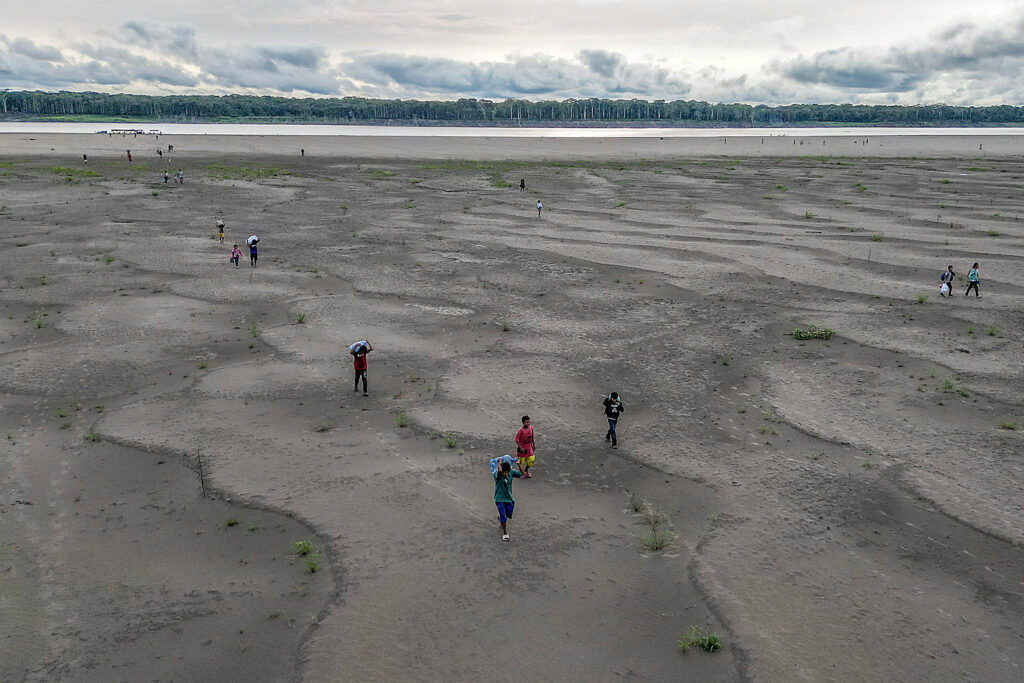
Already Visible Impacts Below the Threshold
Even below the 1.5°C threshold, the effects of a warming climate are evident. California reservoirs no longer fill in some years and overflow with extreme rainfall in others. Coral reefs from Australia to the Caribbean have bleached beyond recovery, and vast tracts of forests have burned in megafires. Traditional crop calendars no longer align with seasons, and deadly nighttime heat rises in cities, killing vulnerable people in apartments that never cool. These impacts underscore the stakes of a potential super El Niño. In 2024, Earth experienced the hottest year recorded in human history, aided by an El Niño boost. A strong El Niño in the next 12 to 18 months could push the planet past 1.5°C, with effects that may be irreversible on human timescales.
What Comes Next: Odds and Open Questions
The updated models give 2026 a 56% chance of being the second warmest year on record, a 26% chance of being the warmest, and a 34% chance of exceeding 1.5°C. The 2027 estimate remains highly uncertain, with a range from 1.4°C to 1.93°C, depending on the strength of the El Niño and the trajectory of global warming. Scientists caution that predictions remain within the 'spring predictability barrier,' when it is historically difficult to forecast El Niño development. But the convergence of models on a strong event has raised alarms. The coming months will be critical for monitoring ocean temperatures and atmospheric patterns that could confirm whether the Pacific is about to boil over.
The bottom line
- A super El Niño in 2026 could push global temperatures past 1.5°C permanently, with cascading effects on weather, ecosystems and agriculture.
- The latest models project a peak anomaly of 2.7°C in the tropical Pacific, comparable to the 2015/2016 event.
- Super El Niños can trigger abrupt, lasting climate regime shifts, according to a December 2025 study.
- The Eastern Pacific hurricane season may start early, with NOAA monitoring potential development off Mexico in mid-May.
- Even below 1.5°C, impacts like reservoir failures, coral bleaching and deadly heat are already occurring and will worsen.


Plymouth WWII bomb defused: 1,200 homes evacuated as 250kg device made safe

Bank of England Holds Rates at 3.75% as Iran War Fuels Inflation Fears

Russia Launches Over 400 Drones in Daytime Attack on Ukraine, Injuring 10 in Ternopil