UK Braces for Thundery Bank Holiday as Warm Spell Collapses
After the warmest day of the year in Scotland, a cold front brings heavy showers and a sharp drop in temperatures across the country.

UNITED KINGDOM —
Key facts
- Temperatures in southeast England could reach 26°C on Friday before a cold front arrives.
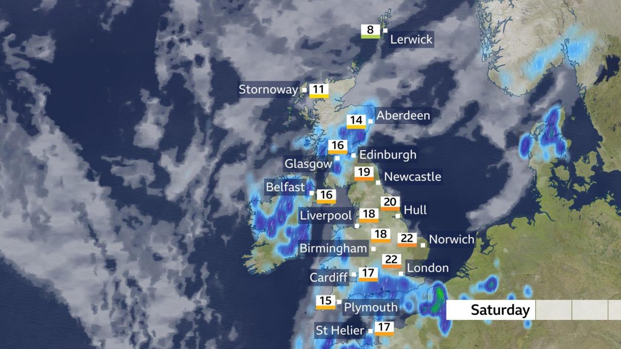
- Saturday will see highs of only 13°C in parts of Scotland, down from 23.9°C on Thursday.
- The Met Office warns of heavy, thundery showers across Northern Ireland, Scotland, Wales and western England.
- More than 4 million journeys are expected on major roads on Saturday, the busiest early May bank holiday in 10 years.
- Eastern England may see 25°C on Saturday, while the rest of the country struggles to reach the mid-teens.
- The long-range forecast suggests a return to more settled, drier conditions later in May.
- May's full 'Flower Moon' will rise on Friday 1 May, with spring flowers in full bloom.
Warm Start Gives Way to Unsettled Weekend
After a spell of unseasonable warmth that saw temperatures climb to 26°C in parts of southeast England on Friday, the United Kingdom is bracing for a dramatic shift in weather as the early May bank holiday weekend begins. A cold front pushing eastwards will bring cloud, showers and significantly cooler air across Northern Ireland, Scotland, Wales and western England, with some of the showers expected to be heavy and thundery. The change comes just as millions of Britons prepare to travel, with the RAC motoring group predicting the busiest early May bank holiday on the roads in a decade. Saturday alone is expected to see more than 4 million journeys on major roads, adding to the challenge of navigating the deteriorating conditions.
Temperature Plunge from Record Highs
Thursday marked the warmest day of the year so far in Scotland, with temperatures reaching 23.9°C in Achnagart in the Highlands. By Saturday, however, afternoon highs in the same region will struggle to reach 13°C, a drop of nearly 11 degrees in just two days. Across most of the UK, apart from eastern England, temperatures will not rise much past the mid-teens. Eastern England remains a relative outlier, with forecasts of up to 25°C on Saturday, centred on areas such as Nottingham, Leicester, Peterborough and Cambridge.ven there, the warmth will be short-lived as cooler air spreads eastward through the weekend.
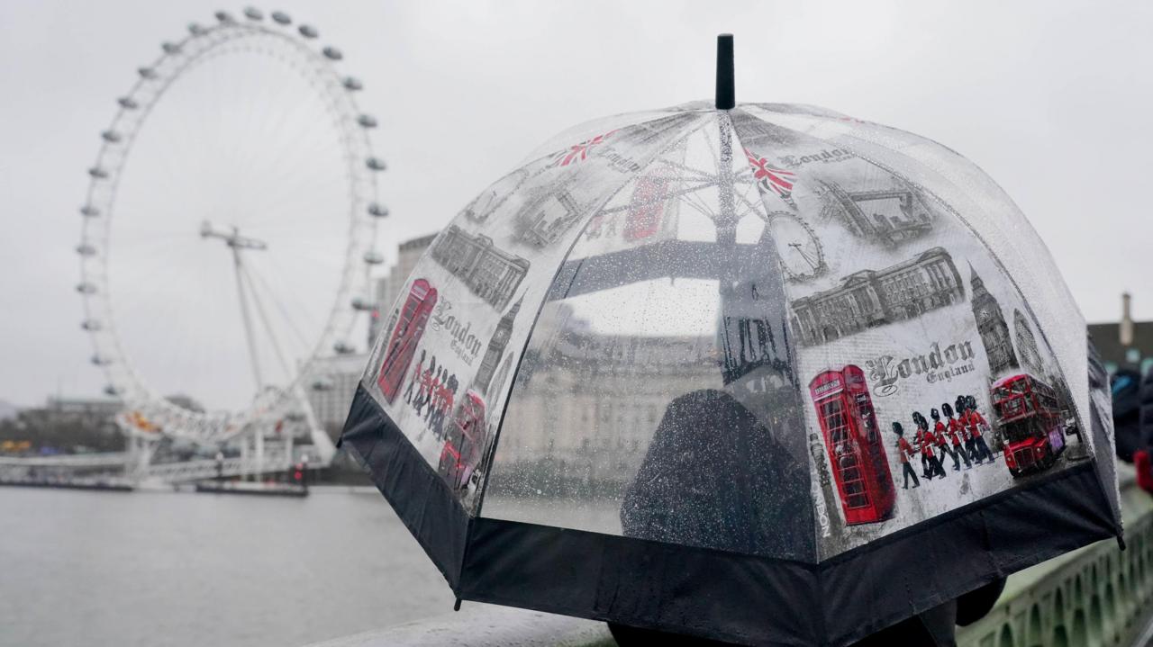
Thundery Showers and Soaking Rain in the South
The Met Office has forecast wet weather and heavy downpours across southern parts of the UK throughout the weekend. Meteorologist Alex Deakin warned that some areas in the south of England could get a “real soaking”. On Saturday, showers will become more widespread across eastern and southern England into the late afternoon and evening, while Northern Ireland and Scotland experience heavy, thundery downpours from the morning. Met Office deputy chief forecaster Tom Crabtree said: “By Friday, conditions are expected to become more unsettled, with rain and showers spreading in from the southwest, some of which could be heavy and possibly thundery. Into the Bank Holiday weekend, the weather looks more changeable, with showers at times – particularly in the north – but also some sunnier intervals.”
Bank Holiday Monday: Cooler and Showery
The unsettled weather is expected to persist through the entire bank holiday weekend, with temperatures falling below 20°C across the country by Monday. Northern areas may remain largely dry, but southern regions will continue to see showers, some heavy. The Met Office’s Grahame Madge noted: “On Saturday, we've got the prospect of some quite heavy, thundery showers coming…into parts of southern England. We've got quite widespread showers overnight Saturday and into Sunday, and then we'll start to see from Sunday onwards, a cooler influence coming in, bringing some showers.” Sunday will bring temperatures in the mid-to-late teens for parts of Wales and southern England, while the north of the UK will see slightly cooler conditions. The outlook for early next week suggests further showers on Monday, heavy and thundery at times, before turning cooler with a mix of sunny spells and lighter showers.
Long-Range Outlook: A Return to Drier Weather?
Looking further ahead, the Met Office’s long-range forecast for 6 to 15 May indicates a fairly quiet start to the period, with many areas seeing a good deal of dry weather. However, the completely dry and warm conditions seen in recent days are unlikely to return immediately; clear or sunny periods and showers are more probable. After a cold start, especially in the north, temperatures are expected to return close to average later in the period. For the second half of May, from 16 to 30 May, low pressure systems are likely to dominate, bringing showers or longer spells of rain at times, heavy in places. There will be some dry and warm interludes, but temperatures are likely to remain close to normal overall. Toward the end of the month, more settled and drier conditions may begin to develop, with temperatures perhaps rising slightly above normal.
A Mixed Picture for Holidaymakers
The early May bank holiday weekend, traditionally a time for outdoor activities and travel, will this year require flexibility and preparation. The RAC’s warning of the busiest roads in a decade, combined with the Met Office’s forecasts of heavy rain and thunderstorms, means that millions of people will face both congestion and challenging weather. The full 'Flower Moon' rising on Friday 1 May, as explained by BBC Weather’s Darren Bett, may offer a brief moment of beauty before the clouds roll in. For those hoping to salvage the weekend, the best advice is to plan for changeable conditions: sunny spells one moment, heavy showers the next. Eastern England offers the best chance of warmth and sunshine on Saturday, but by Sunday the cooler, wetter weather will have spread nationwide. The message from forecasters is clear: enjoy the warmth while it lasts, but be ready for a dramatic shift.
The bottom line
- A cold front will end the warm spell, bringing heavy, thundery showers and a sharp temperature drop across the UK.
- Saturday is the busiest early May bank holiday on the roads in 10 years, with over 4 million journeys expected.
- Eastern England may see 25°C on Saturday, but most of the UK will struggle to reach the mid-teens.
- The unsettled weather will persist through Monday, with temperatures falling below 20°C nationwide.
- Long-range forecasts suggest a return to drier, more settled conditions later in May, but with temperatures near normal.


Rajasthan Royals vs Delhi Capitals: Parag Salvages Powerplay After Openers Fall Early
Barney Walsh teases father Bradley in new series of ITV's Breaking Dad

She Loved a Killer: The Cyclist Buried, the Girlfriend Who Turned Informant