Arctic air sends UK temperatures plunging 10°C after balmy bank holiday weekend
Widespread frost and sub-zero overnight lows expected across Scotland and northern England as a northerly airflow replaces last week's exceptional warmth.

UNITED KINGDOM —
Key facts
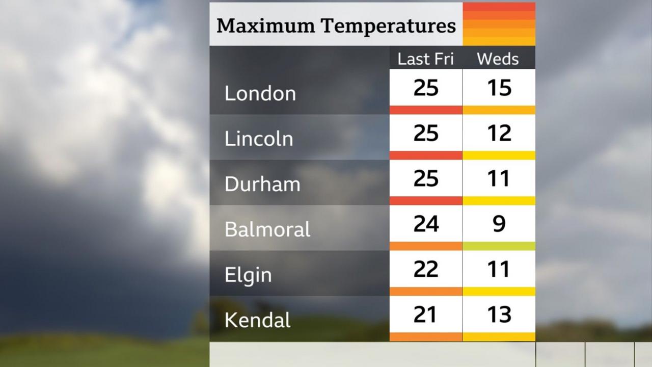
- Temperatures peaked around 25°C (77°F) in parts of England on Friday.
- Midweek highs will be just 7-8°C in the north and 15°C in the south — a drop of roughly 10°C.
- Overnight temperatures could fall to -4°C in eastern Scotland and -1°C in northern England early Wednesday.
- In rural glens of Caithness, Sutherland and the north west Highlands, lows may reach -5°C.
- Monday night saw 0.6°C in Lerwick, Shetland.
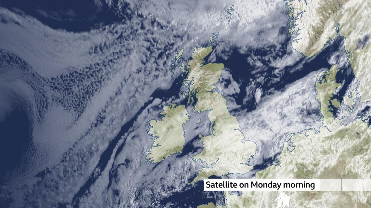
- A northerly airflow from the Arctic is driving the cold snap.
- By Thursday, winds shift to south-southwesterly, bringing milder conditions.
- Average early-May temperatures are 12°C in the north and 15°C in the south.
Bank holiday warmth gives way to a dramatic chill
After a balmy bank holiday weekend when temperatures touched 25°C in parts of England, the first full week of May has brought a sharp reversal. A mass of Arctic air sweeping southward has driven thermometers down by as much as ten degrees, with widespread frost and sub-zero overnight lows forecast from Scotland to northern England. The change is stark but not unprecedented. Last week's heat was exceptional for late April; the current values are closer to the seasonal norm. Yet the speed of the transition — from shirt-sleeve warmth to the risk of snow on the highest Munros — has caught many off guard.
A northerly airflow delivers an 'Arctic plunge'
The culprit is a large area of high pressure anchored over the Atlantic, which has placed the United Kingdom in a persistent northerly airflow. Meteorologists describe this as an 'Arctic plunge' — a term that simply means cold air moving in from the north. The wind direction is the key: a northerly always brings chillier conditions because it originates over the Arctic, a cold region at all times of year. By contrast, a southerly wind taps into warm tropical air from the Sahara or southern Europe, boosting temperatures. An easterly wind's effect depends on the season: bitterly cold in winter, but often warm and dry in summer.
Overnight frost and sub-zero lows expected
The coldest night of the week is expected to be Tuesday into Wednesday, when largely dry and clear skies with light winds will allow temperatures to plummet. In eastern Scotland, lows could reach -4°C, with -1°C in northern England and a widespread frost. In rural glens of Caithness, Sutherland and the north west Highlands, the mercury may dip to -5°C. Monday night already saw 0.6°C in Lerwick, Shetland. Wednesday morning will start frosty and chilly for many, with patchy ground frost more widespread than earlier in the week. Over the highest Munros, any lingering showers may fall as snow.
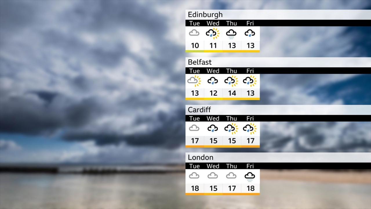
Midweek: the coolest day with slow-moving downpours
Wednesday is likely to be the coolest day of the week, as a gentle northerly flow takes hold. The forecast calls for sunny periods interspersed with occasional slow-moving downpours, most frequent across Scotland, northern England, the Midlands and Wales. In the south, sunshine will be more limited, with a greater chance of lively showers and even an isolated rumble of thunder. Tuesday began on a chilly note, with early fog clearing to leave sunny spells but also a scattering of showers. Monday night felt fresher, with ground frost possible across Scotland and Northern Ireland.
Thursday brings a return to milder southwesterly winds
By Thursday, the wind direction shifts to a more south-southwesterly flow, which will start to recover temperatures. A brisk wind in the northwest, close to low pressure, will bring steady rain to Scotland, while most other parts see only showery bursts. The change will make conditions feel milder and less chilly, though the general weather pattern remains unsettled and changeable. This return to a milder regime is typical for early May, but the abruptness of the cold snap has underscored how variable spring weather can be.
What the cold means for gardeners and commuters
The return of ground frost and pockets of fog, though short-lived at this time of year, is worth noting for those with delicate plants outdoors. Under the clearest skies, the frost could be damaging to tender vegetation. Commuters should also be aware of potentially icy patches on untreated roads, especially in northern areas. Despite the chill, the week will bring a mix of conditions — primarily dry weather with showers here and there. The strengthening May sun will still feel springlike and pleasantly warm in sheltered spots when it breaks through.
A sharp reminder of spring's volatility
The dramatic temperature swing from 25°C to near-freezing nights within days is a vivid illustration of spring's inherent instability. While the cold air is not unusual for early May — average highs are 12°C in the north and 15°C in the south — the contrast with last week's exceptional warmth makes it feel more severe. As the week progresses, the recovery to milder conditions will be gradual, and the outlook remains changeable. For now, the United Kingdom is in the grip of a brief but sharp Arctic interlude, a reminder that even in May, winter is never far away.
The bottom line
- Temperatures dropped roughly 10°C from last week's peak of 25°C to midweek highs of 7-15°C.
- Overnight lows could reach -5°C in Scottish glens, with widespread frost across Scotland and northern England.
- A northerly Arctic airflow is the direct cause of the cold snap; wind direction is the primary driver.
- The cold is short-lived: by Thursday, southwesterly winds will bring milder air and temperatures will recover.
- The week will feature a mix of sunny spells, slow-moving downpours, and isolated thunder, with snow possible on high ground.
- While the chill is notable, last week's heat was exceptional; current values are near or slightly below the seasonal average.


In 'The Cage,' a Casino Heist Becomes a Devastating State-of-the-Nation Drama

Lakers Face Uphill Battle Against Thunder Without Dončić in Western Conference Semifinals
