Delhi-NCR Braces for More Storms as Powerful Trough Brings Rain to Northwest India
A strengthening atmospheric trough drawing moisture from both seas is set to trigger a series of western disturbances from May 4 to 7, threatening sudden storms and travel disruptions.

INDIA —
Key facts
- Delhi received rain and thunderstorms on Saturday, with a maximum temperature of 38.6°C at Safdarjung.
- IMD issued a yellow alert for Delhi for the next two days, predicting light rain with winds of 30-50 km/h.
- A fresh western disturbance is expected to create a cyclonic circulation, with no heatwave likely for a week.
- Rajasthan, Uttarakhand, Haryana, Punjab, and Uttar Pradesh are experiencing intense storm activity.
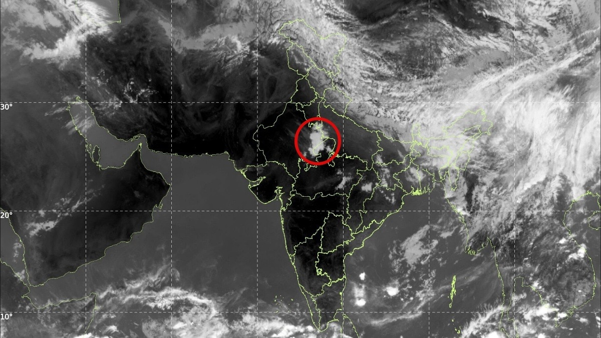
- A massive trough is strengthening, drawing moisture from the Arabian Sea and Bay of Bengal.
- Meteorologists warn of strong western disturbances between May 4 and May 7 across northwest India.
- Delhi-NCR skies are currently clear but forecasters caution conditions could change quickly.
Rain and Thunderstorms Break Heatwave in Delhi-NCR
Delhi experienced a spell of rain and thunderstorms on Saturday, offering a much-needed respite from the rising temperatures that had gripped the city. Visuals showed rain battering parts of the national capital, accompanied by stormy weather in adjoining areas of the National Capital Region (NCR). The India Meteorological Department (IMD) had predicted the change earlier in the day, issuing a yellow alert for the capital for the next two days. An IMD official stated that "a spell of very light to light rain, accompanied by thunderstorms, lightning, and strong winds of 30-40 km/h, gusting up to 50 km/h, is likely to occur on Sunday" with similar conditions persisting into Monday. This rainfall comes just two days after Delhi and its surrounding regions experienced hailstorms and rain amid an intense heatwave spell, providing a major relief to residents.
Temperatures Dip but Remain Above Normal
The maximum temperature in Delhi on Saturday was recorded at 38.6 degrees Celsius at Safdarjung, 0.7 degrees below normal for this time of year. However, this was 2.2 degrees Celsius higher than the previous day, indicating a temporary fluctuation rather than a sustained cooling trend. The minimum temperature at Safdarjung stood at 25.9 degrees Celsius, which is 1.2 degrees above normal. The IMD's yellow alert underscores the potential for further weather-related disruptions as the region navigates the transition from heatwave conditions to stormy weather.
Western Disturbance to Influence Weather for Days
Private weather channel Skymet's vice president Mahesh Palawat noted that "a fresh western disturbance is expected to influence the region in the coming days, leading to a cyclonic circulation over adjoining areas." He added that "light rain might occur in parts of the city for the next few days, and there is no possibility of a heatwave at least for the next week." This disturbance is part of a larger atmospheric pattern affecting northwest India. A powerful weather system has already triggered intense rainfall and storms over large parts of Rajasthan, with conditions expected to evolve further. Meteorological observations indicate that the system is impacting regions of Haryana, Punjab, and Uttar Pradesh, while gradually shifting southwards toward northern Madhya Pradesh.
Neighbouring States Hit by Hailstorms and Heavy Rain
Neighbouring states including Uttarakhand and Rajasthan also witnessed spells of rainfall on Saturday. Dehradun experienced a hailstorm after a day of fluctuating sunshine and clouds, while several districts in particularly intense storm activity with strong winds, lightning, and heavy showers. Parts of Haryana and northern Madhya Pradesh are also experiencing scattered rainfall and localized storm development as the system expands. The widespread activity highlights the reach of the current weather system, which is drawing moisture from both the Arabian Sea and the Bay of Bengal.
Strengthening Trough Raises Risk of Severe Storms
Despite the widespread activity nearby, Delhi-NCR remains largely clear for now. However, forecasters caution that this may change soon. A massive and active trough, a key atmospheric feature driving the current instability, is strengthening over the region. This trough is drawing in moisture-laden winds from both the Arabian Sea and the Bay of Bengal, creating conditions favourable for further weather intensification. Meteorologists warn that this convergence of moisture and winds is likely to trigger a series of strong western disturbances between May 4 and May 7. These systems are expected to impact large parts of northwest India, potentially bringing widespread rainfall, thunderstorms, and gusty winds.
Delhi-NCR Faces Uncertainty as Weather Models Shift
For Delhi-NCR, the key question remains timing. While skies are currently clear, the proximity of active systems suggests a rising likelihood of rain and storm activity in the coming days. Weather models indicate that any shift in the system's trajectory or strengthening of the trough could quickly change local conditions. Residents across the region are advised to stay updated with official forecasts, as rapidly evolving weather patterns may lead to sudden storms, temperature drops, and travel disruptions. The IMD's yellow alert serves as a precautionary measure, urging preparedness for potential hazards associated with thunderstorms and strong winds.
Outlook: No Heatwave for a Week but Storm Risk Persists
The immediate outlook for Delhi-NCR suggests a break from the recent heatwave, with no extreme temperatures expected for at least the next week. However, the risk of thunderstorms and gusty winds remains elevated due to the active trough and incoming western disturbances. The convergence of moisture from two seas and the strengthening trough create a volatile atmospheric setup. While the precise timing and intensity of storms remain uncertain, the pattern indicates a period of unsettled weather across northwest India. Authorities and residents alike must remain vigilant as the region transitions from scorching heat to potential stormy conditions.
The bottom line
- Delhi-NCR received rain and thunderstorms on Saturday, breaking a recent heatwave with temperatures reaching 38.6°C.
- IMD has issued a yellow alert for Delhi for Sunday and Monday, predicting light rain with strong winds up to 50 km/h.
- A fresh western disturbance will bring cyclonic circulation, with no heatwave expected for the next week.
- A powerful trough drawing moisture from the Arabian Sea and Bay of Bengal is strengthening, threatening severe storms from May 4 to 7.
- Neighbouring states like Rajasthan, Uttarakhand, Haryana, and Punjab are already experiencing intense storm activity.
- Delhi-NCR skies are currently clear but forecasters warn conditions could change rapidly due to the active trough.


Bihar Public Service Commission Reintroduces 'Option E' Rule, Mandating Attempt Mark on Every MCQ

President Murmu Calls for Peace and Inclusivity as India Marks Buddha Purnima 2026

EC Orders Repoll in All 285 Falta Booths After Irregularities; Peaceful Voting Underway