Massive Cold Front to Plunge Temperatures 30 Degrees Below Average Across US
A sprawling system threatens severe storms, flooding, and snow from the Northern Plains to the Deep South, with record-low highs possible in Texas.

NEW ZEALAND —
Key facts
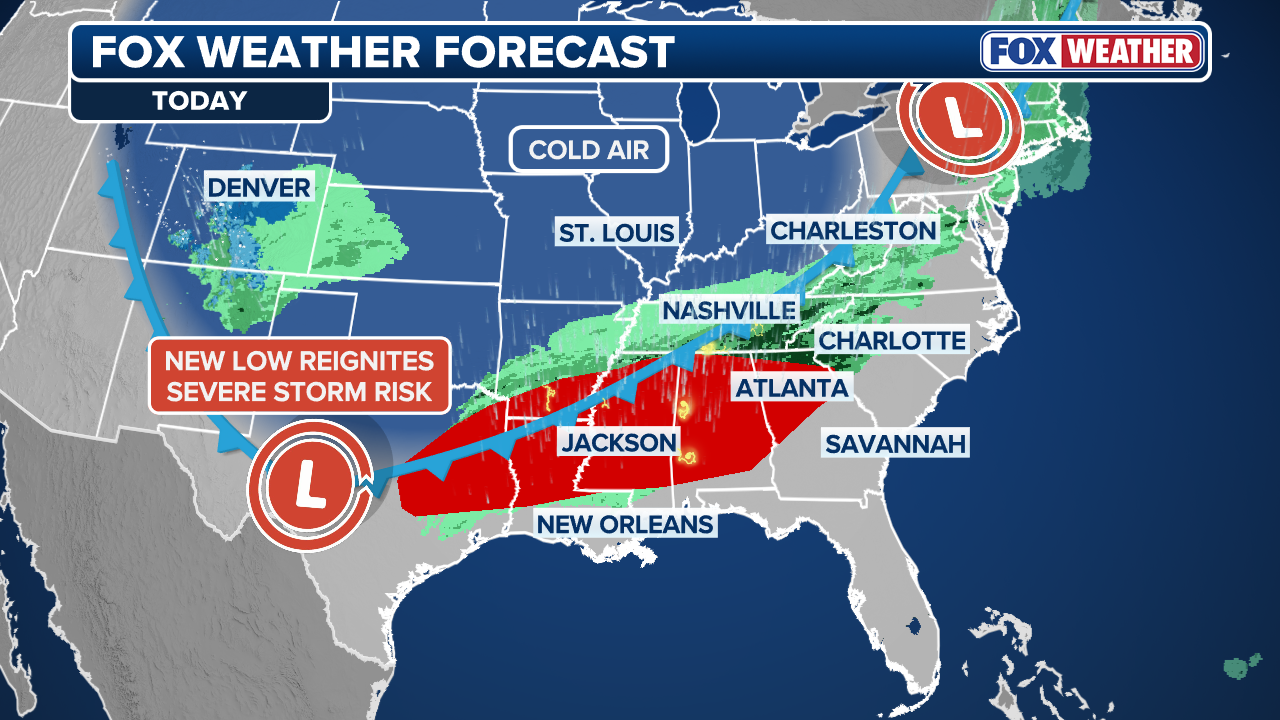
- Cold front moves into Northern Plains and Midwest on Monday, sweeping across most of the US through the week.
- Temperatures expected to drop 20 to 30 degrees below average, resembling early March rather than early May.
- Severe storms target Midwest, Great Lakes, Southern Plains, and Deep South with damaging winds, large hail, tornadoes, and flash flooding.
- Heavy rain forecast for Northeast; snow for higher elevations in Northern Plains and Rockies.
- Potential for significant air travel delays in eastern and Central US, including Denver.
- Texas faces a 'light freeze' possible; record low maximum temperatures predicted with highs in 40s and 50s.
- Rain chances in Austin, San Antonio, and Houston peak at 95% on Friday, May 1.
A Polar Plunge in Early May
A massive cold front is set to barrel across the United States this week, bringing a dramatic temperature drop that will make early May feel like early March. The system, which will move into the Northern Plains and Midwest on Monday, is expected to sweep over most of the country, ushering in severe storms, flooding rain, and snow for higher elevations. Behind the front, millions of Americans will see temperatures plunge 20 to 30 degrees below seasonal averages. In Texas, where residents were preparing for swim season, a 'light freeze' is possible, with some locations forecast to see highs in the 40s and 50s—far below the historical average of 70s to near 80.
Severe Weather Targets Storm-Weary Regions
After a volatile April that saw destructive tornadoes, including one that tore across Vance Air Force Base in Enid, Oklahoma, on April 23, and caused damage in Mineral Wells, Texas, on April 28, the pattern remains unsettled. The cold front will bring multiple rounds of storms to the Midwest and South, threatening damaging winds, large hail, tornadoes, and flash flooding. Severe weather will spread across the Midwest and Great Lakes late Monday before reaching the Southern Plains and the Deep South by mid-week. The northern half of the front will then bring heavy rain to the Northeast, while snow wraps behind the front across the Northern Plains and the Rockies.
Record Lows and Travel Disruptions
AccuWeather Meteorologist Brandon Buckingham warned that 'some record low maximum temperatures may be set in the Southern states,' with highs in the 40s and 50s in some locations. The National Weather Service Climate Prediction Center is forecasting temperatures falling below seasonal averages across Texas as it heads into the first week of May. The sprawling system also has the potential to cause significant air travel delays in the eastern and Central US, as well as Denver, as the front drags across the nation through the week.
Texas Cities Brace for Cold and Rain
In Texas, the cold snap is part of a broader severe weather outlook that includes tornadoes and storms in North Texas, drought in South Texas, and prime wildfire conditions in the Texas Panhandle. Austin, San Antonio, and Houston will see cool and rainy weather. According to the National Weather Service in San Antonio, the state capital will see highs in the high 60s to mid-70s over the weekend, with lows in the 50s. San Antonio will experience similar conditions. Rain is set to impact the region starting Thursday, April 30, with an around 60% chance, climbing to 95% on Friday, May 1, then tapering out over the weekend.
Dallas-Fort Worth: Sunny but Cold
In Dallas and Fort Worth, the 'temperatures will be well below normal, with highs in the 50s to lower 60s' on Friday, May 1, with chances of rain. However, skies should turn clear and sunny, with temperatures in the 70s, but lows will remain well below normal, in the 50s to lower 60s on Saturday and Sunday. The contrast between sunny skies and cold temperatures underscores the unusual nature of this early May cold snap.
Outlook: A Quieter May After April's Storms?
The pattern shift that brings this cold front may also signal a quieter month ahead after April's stretch of destructive storms. However, the immediate threat remains severe, with millions facing multiple hazards. As the front sweeps across the country, residents are advised to monitor local forecasts and prepare for sudden weather changes, from tornadoes to snow. The cold air will linger, reminding many that spring has not yet fully arrived.
The bottom line
- A massive cold front will cause temperatures to drop 20-30 degrees below average across much of the US, with record low highs possible in the South.
- Severe storms, including tornadoes and flash flooding, threaten the Midwest, South, and Great Lakes through mid-week.
- Heavy rain and snow will impact the Northeast and higher elevations, respectively.
- Significant air travel delays are expected, particularly in the eastern and Central US and Denver.
- Texas faces a 'light freeze' and rain chances up to 95% on May 1, with cool temperatures persisting through the weekend.
- The cold snap follows a volatile April of tornadoes and storms, but may precede a quieter May.


Auckland FC survive Melbourne City scare to reach A-League semi-finals in dramatic penalty shootout

76ers complete historic 3-1 comeback, stun Celtics 109-100 in Game 7

Hayley Holt, Former Breakfast Host, Eyes Reality TV Comeback After Year Off Screens