New Zealand Braces for Unsettled Weather with Heavy Rain and Flood Risk
Two weather systems are set to bring significant rainfall, strong winds, and warmer temperatures across the South Island and parts of the North Island.

NEW ZEALAND —
Key facts
- MetService has issued heavy rain warnings and watches for western and northern South Island regions.
- Tasman District could receive up to 400mm of rain in some areas.
- Buller District ranges may see up to 300mm of rain.
- Westland District ranges are forecast to receive up to 300mm of rain.
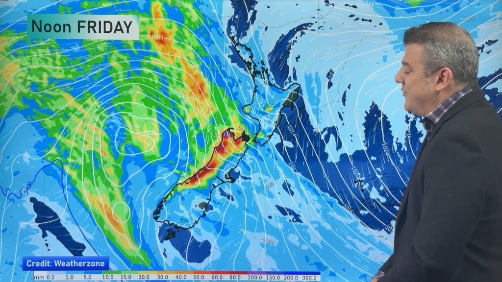
- A second weather system is expected to bring further heavy rain and strong winds from Friday.
- Warmer overnight temperatures are anticipated with the unsettled conditions.
- A cooler airflow with frost potential is expected by Sunday and Monday.
Nation Faces Dual Weather Threats
New Zealand is preparing for a significant spell of unsettled weather as two consecutive weather systems are poised to sweep across the country. These fronts are expected to deliver heavy rain, strong winds, and unseasonably warm overnight temperatures, prompting insurers and infrastructure managers to monitor the situation closely. The approaching systems carry potential implications for property, infrastructure, and business continuity across various sectors. The first weather system began moving northwards over the South Island, bringing heavy rain. This was followed by a second system expected to move across the nation from Friday, potentially prolonging wet conditions and increasing the risk of further impacts if rivers and catchments remain high. MetService meteorologist Braydon White noted that recent dry spells are likely to give way to more typical late-autumn conditions. "The wetter side of autumn is set to come back with a bang," White stated, anticipating heavier rainfall on already moist ground. This combination, coupled with warmer air, could alter claims patterns, particularly concerning drainage, slope stability, and stream capacity.
South Island Bears the Brunt of Rainfall
The most significant rainfall totals are anticipated along the western ranges of the South Island. An orange heavy rain warning is in effect for the Westland District ranges from Wednesday evening into Thursday. Heavy rain watches have also been issued for Fiordland north of Doubtful Sound, the headwaters of Otago lakes and rivers, and the headwaters of Canterbury lakes and rivers. Specific forecasts indicate that Tasman District, northwest of Motueka, could receive between 350mm and potentially 400mm of rain by Thursday evening. Peak rainfall rates of 25 to 30mm per hour are expected during Thursday, with the possibility of thunderstorms. The Buller District ranges are forecast to receive up to 300mm of rain over 33 hours from Thursday morning, with rainfall rates potentially reaching 15 to 25mm/h. Westland District is facing a 23-hour heavy rain warning, with up to 300mm expected in the ranges, particularly about and south of the glaciers. Peak rates of up to 35mm/h were anticipated for Thursday, with another period of heavy rain expected from Friday afternoon. These conditions raise concerns about surface flooding, slips, and transport disruptions.
North Island Faces Moderate Conditions
While the South Island faces the most severe weather, the North Island is also expected to experience rain and showers. Northland, Auckland, and Coromandel are forecast to see cloudy periods and isolated showers, with rain spreading through the day. Auckland is predicted to reach a high of 20°C, while Whangārei is expected to reach 19°C. From Waikato to Whanganui, including the Bay of Plenty and the central high country, Tuesday's outlook included morning and evening cloud with isolated showers. Coastal Bay of Plenty could experience showers by Tuesday night. Gisborne to Wairarapa may see morning frosts giving way to cloudy periods and showers north of Tolaga Bay. Across Manawatū to Wellington, areas of morning and evening low cloud are expected, interspersed with fine spells. The capital is forecast to reach a high of around 15°C. The overall pattern suggests a distinction between higher-risk zones and more moderate conditions elsewhere.
Broader Implications and Insurer Scrutiny
The unsettled weather pattern is drawing the attention of insurers and brokers, who are monitoring the developing systems for their potential impact on various lines of business. Property, infrastructure, and business interruption exposures are key areas of focus. The combination of heavier rainfall on saturated ground, coupled with warmer air, can significantly alter claims patterns. Areas prone to surface flooding, slope instability, and constrained stream capacities are particularly vulnerable. The potential for transport disruption, including motor and marine claims, adds another layer of concern. MetService has indicated that further warnings and watches are likely in the coming days as the second weather system develops. This suggests that the period of elevated risk may extend beyond the initial forecasts, requiring ongoing vigilance from affected parties and emergency services.
Transition to Cooler Air
Following the period of unsettled weather, a notable shift in conditions is anticipated. By Sunday and Monday, a cooler or colder airflow is expected to cover most regions of the country. This transition will coincide with easing winds, which will bring with them the potential for frost across many areas. This cooler spell is expected to precede the arrival of another powerful high-pressure zone. The contrast between the current warmer, wetter conditions and the impending cooler air highlights the dynamic nature of New Zealand's autumn weather, presenting distinct challenges and opportunities for different sectors.
The bottom line
- Two weather systems are bringing heavy rain and strong winds to New Zealand, primarily affecting the South Island.
- Tasman, Buller, and Westland districts are forecast to receive significant rainfall totals, increasing flood and slip risks.
- The North Island will experience rain and showers, with Auckland and other northern regions seeing moderate temperatures.
- Insurers are closely monitoring the weather for potential impacts on property, infrastructure, and business interruption.
- A cooler airflow with frost potential is expected to move in by Sunday and Monday, following the current wet spell.
- MetService warns that further weather advisories may be issued as the situation develops.


US KC-135 Stratotanker Vanishes Over Qatar After Sending Distress Signal

Massive Cold Front Unleashes Tornadoes, Hail, and Snow Across 25 States, Strikes China and Russia
