Tonga Completes National Lidar Mapping to Bolster Climate Resilience
A comprehensive Lidar survey aims to provide crucial data for adaptation planning and infrastructure development in the Pacific island nation.

UNITED KINGDOM —
Key facts
- Tonga will achieve comprehensive national Lidar coverage in 2026.
- The Tonga Coastal Resilience Project is funded by the Green Climate Fund.
- A Lidar survey of Tongatapu and Ha’apai island groups concluded in April 2026.
- Fugro, a geodata specialist, conducted the recent Lidar survey.
- Previous Lidar surveys were conducted in 2012 and 2021.
- A new hotel, Grand Tonga Hotel, is under construction in Fangaloto.
- The Grand Tonga Hotel is projected for completion in late 2027.
- Cyclone Gita influenced the design of the new hotel.
A New Era of Climate Data for Tonga
The Kingdom of Tonga is on the cusp of becoming one of the few Pacific Island Countries to possess complete national Lidar coverage, a significant stride toward enhancing climate resilience and informing national planning. This ambitious undertaking, slated for completion in 2026, is being realized through the Tonga Coastal Resilience Project (TCRP), a joint initiative supported by the Green Climate Fund (GCF) and steered by the United Nations Development Programme (UNDP) in collaboration with the Tongan government. The project aims to equip Tonga with its inaugural comprehensive national Lidar baseline. This data will be instrumental in refining coastal risk models, projecting the impacts of sea-level rise, bolstering disaster preparedness, and guiding future infrastructure development. It represents a critical investment in evidence-based adaptation strategies for a nation acutely vulnerable to climate change. The initiative underscores a broader effort to strengthen Tonga's capacity in managing and interpreting vital coastal and climate risk data. By establishing robust geospatial data systems and cultivating national technical expertise, Tonga is building a foundation for informed decision-making that promises to safeguard its communities, infrastructure, and natural environment for generations.
Mapping the Coastlines for Future Protection
A crucial phase of this national mapping effort involved a Lidar coastal survey conducted from March 21 to April 18, 2026. This survey meticulously covered the Tongatapu and Ha’apai island groups, adding vital data to the nation's growing geospatial repository. The work was executed by Fugro, an international firm renowned for its expertise in aerial and maritime mapping. Throughout the survey's implementation, technical teams from the Pacific Community (SPC) and Fugro collaborated closely with Tonga's Ministry of Lands, Survey, Planning and Natural Resources. This partnership ensured a robust transfer of knowledge and technical skills to the national Mapping and Surveying Division. Key ministries, including those responsible for Meteorology, Energy, Information, Disaster Management, Environment, Climate Change, Communications (MEIDECC), and Infrastructure (MOI), were also integral to the coordination efforts. The data gathered will be pivotal in developing scenario-based coastal risk maps and informative products. These resources will empower evidence-based adaptation planning, moving beyond mere data acquisition to foster genuine national ownership of climate information systems and build lasting technical capacity within government institutions.
Building on Past Efforts, Charting Future Needs
The 2026 Lidar survey represents the culmination of a phased approach to national mapping. Prior efforts laid the groundwork for the current comprehensive coverage. In 2012, a survey funded by the Australian Department of Foreign Affairs and Trade (DFAT) under its Climate Change Science and Adaptation Program (PACCSAP) mapped Tongatapu, Lifuka, and Foa islands. Subsequently, in 2021, a survey supported by the World Bank's Pacific Resilience Program (PREP) extended coverage to include ‘Eua, Vava’u, Tafahi, and Niuatoputapu. The current 2026 survey, funded by the Green Climate Fund through the TCRP, focuses on Tongatapu and the Ha’apai Islands, thereby completing the national Lidar coverage. By integrating these existing datasets, Tonga is establishing its first unified national Lidar coverage. This advancement is expected to yield high-resolution evaluation data, enabling more precise flood and coastal inundation modelling, safer infrastructure design, enhanced coastal zone management, and more informed long-term adaptation strategies to rising sea levels and extreme weather events.
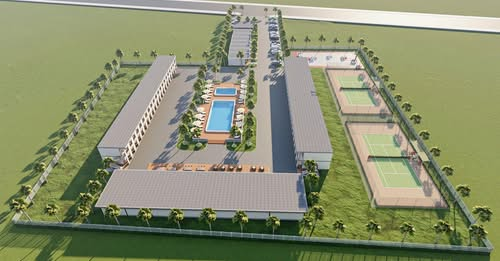
New Hotel Development Underscores Tourism Growth
Beyond climate resilience initiatives, Tonga is also experiencing growth in its tourism sector, highlighted by the development of the Grand Tonga Hotel. Currently under construction in Fangaloto, this new establishment aims to provide affordable, high-quality accommodation while celebrating Tongan culture and hospitality. The hotel is planned to feature approximately 80 rooms, swimming pools, wellness facilities, an event centre, and a full-service restaurant. Its development addresses a growing demand for accommodation driven by tourism, family gatherings, conferences, and regional events. The founders, who have lived in Tonga for nine years after an initial visit in 2016, were inspired by the nation's peaceful environment and the warmth of its people. Recognizing a gap in quality accommodation, particularly during peak periods, the developers are focused on combining affordability with international hospitality standards. Lessons learned from past natural disasters, including Cyclone Gita, have significantly influenced the hotel's design, with construction employing steel framing and durable materials to enhance resilience against local environmental conditions. The project is reportedly nearing its halfway stage, with completion tentatively projected for late 2027, contingent on various logistical factors.
The bottom line
- Tonga is achieving comprehensive national Lidar mapping in 2026, a critical step for climate adaptation.
- The Tonga Coastal Resilience Project, funded by the Green Climate Fund, is driving this mapping initiative.
- Recent Lidar surveys have covered key island groups, with Fugro acting as the geodata specialist.
- This data will enhance coastal risk modelling and infrastructure planning.
- A new hotel development, Grand Tonga Hotel, is progressing and expected to boost tourism infrastructure.
- The hotel's design incorporates resilience lessons from past natural disasters like Cyclone Gita.


Hantavirus Outbreak Linked to Ushuaia Landfill on Cruise Ship

Hantavirus Outbreak on Cruise Ship Leads to Passenger Evacuations
WHO suspects rare human-to-human hantavirus transmission on cruise ship as three die